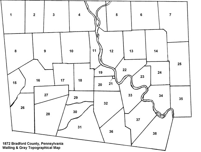
Bradford County was officially organized by the Pennsylvania state legislature in 1812. This map shows how the county was organized at that time.

Townships: (numerical)
| 1. Wells | 11. Ulster | 21. Towanda Boro | 31. Overton |
| 2. South Creek | 12. Sheshequin | 22. Wysox | 32. Monroe |
| 3. Ridgebury | 13. Rome | 23. Standing Stone | 33. Asylum |
| 4. Athens | 14. Orwell | 24. Herrick | 34. Wyalusing |
| 5. Litchfield | 15. Armenia | 25. Pike | 35. Tuscarora |
| 6. Windham | 16. Troy | 26. Canton | 36. Albany |
| 7. Warren | 17. W Burlington | 27. Granville | 37. Terry |
| 8. Columbia | 18. Burlington | 28. LeRoy | 38. Wilmot |
| 9. Springfield | 19. N Towanda | 29. Franklin | |
| 10. Smighfield | 20.Towanda | 30. Barclay |
Townships: (alphabetical)
| Albany (36) | Herrick (24) | Sheshequin (12) | Ulster (11) |
| Armenia (15) | LeRoy (28) | Smithfield (10) | Warren (7) |
| Asylum (33) | Litchfield (5) | South Creek (2) | Wells (1) |
| Athens (4) | Monroe (32) | Springfield (9) | W Burlington (17) |
| Barclay (30) | N Towanda (19) | Standing Stone (23) | Wilmot (38) |
| Burlington (18) | Orwell (14) | Stevens | Windham (6) |
| Canton (26) | Overton (31) | Terry (37) | Wyalusing (34) |
| Columnia (8) | Pike (25) | Towanda (20) | Wysox (22) |
| Franklin (29) | Ridgebury (3) | Troy (16) | |
| Granville (27) | Rome (13) | Tuscarora (25) |
Source:
Sketched by Mark Daly from New Topographical Atlas of the State of Pennsylvania with Descriptions Historical, Scientific and Statistical Together with a Map of the United States and Territories by Professor Henry F. Walling (Lafayette College, Easton PA) and O. W. Gray, Civil & Top'l Engineer (10 North Fifth Street, Philadelphia). Published by Stedman, Brown & Lyon, Philadelphia 1872.
